For the past month I have had my house and my time to myself since hubby has been off hunting. I can't lie. I have really enjoyed having the time to myself to do what I want when I want. With John set to return shortly, I decided it was time to mark one more thing off my list and go explore Mountain Loop Highway before it closed for the winter.
The full moon was still shining over Deception Pass as I left the island at 7am.
 |
| A full moon glistens in the early morning sky |
I listened to podcasts while I aimed my car south on I-5 until I took the Hwy 530 exit towards Arlington. I traveled along the highway until I hit the town of Darrington and stopped at a gas station minimart to use the restroom and buy some snacks. Across the street a large mountain dusted with snow loomed and I asked the clerk if she knew the name of it.
"White Horse," she replied. She proceeded to tell me the local story of how it got the name. There was a man who owned a white horse that escaped and eventually the owner was told that it was up on that mountain. A sudden snowstorm came up and when the mountain was covered in snow it looked like the face of the white horse. She wasn't sure if there was enough snow yet to make out the horse face but assured me that when conditions are right, you can see it. I thanked her for the information and continued on my way.
 |
| White Horse Mountain |
I pulled into my first planned stop, Sauk River Trail. It was on my checklist but when I entered the lot I realized I have actually hiked this trail before 10 years ago with my dog at the time, Sadie. We'd ambled along Sauk River, enjoying the large maple leaves underfoot and chatting with a local mushroom hunter. It is a lovely hike, but I was craving new adventures so I returned to Mountain Loop Hwy and continued east. I pulled off the road at the confluence of White Chuck River and Sauk River and checked out the parking lot of the campground there before continuing up to the White Chuck River Overlook, where I again pulled in to check out the historical marker board. I am a history lover and those historical placards just beg me for a road break.
 |
| Historical Marker at White Chuck Overlook |
Logging was an important way of life in this area for many years and a very unique type of movable logging camp was used to house the people that worked in the area.
 |
| Probably Mount Pugh |
Shortly after the road sign the highway turned into a dirt road. I knew that some of the road was unpaved but assumed it would be a well kept gravel road. I could not have been more wrong. In fact, the road was in such poor condition that I second guessed myself for awhile. I slowed down to avoid the deep potholes, seeing the occasional truck parked off the side with what I assumed were probably deer hunters while large yellow leaves gently swirled down from the trees lining the road. I saw a sign informing me that Barlow Pass was 14 miles ahead and realized I was indeed on the correct road.
 |
| leaves and potholes litter the road |
I desperately needed to use the restroom again and stopped at yet another historical placard next to a rustic closed campground. It was a campground named after the Bedal family. I walked around the closed gate to the pit toilet, praying it was unlocked. It was, and it was also fortunate I had some toilet paper stowed in my backpack since there was none in there.
 |
| Bedal family history and heritage |
I explored the campground after using the pit toilet and it is a lovely place where the North and South Forks of the Sauk River converge. I think I will have to come back next summer and camp here.
 |
| A quaint covered eating area at one of the campsites |
After Bedal Campground the road continues next to the South Fork Sauk River with lots of rough campsites next to the river. I saw only two people camped along that section.
It was a lovely cold 28 degree morning with the vegetation covered in frost. The road is a beautiful drive and I stopped again to take some pictures near an unknown lake, enjoying the ability to stop whenever I wanted. I had debated inviting friends to come with me today but decided instead to recharge my introvert batteries by going alone.
 |
| Barlow Pass ahead |
Continuing on to Barlow Pass, I realized that Barlow Pass is the parking place and trailhead for Monte Cristo, an eight mile hike I did a few years ago to an old mining ghost town. There were lots of people parked there doing that hike, rather appropriately doing a ghost town hike this close to Halloween.
Shortly after Barlow Pass I saw the trailhead I was looking for, The Big Four Ice Caves hike. I pulled into the large parking lot, hung my northwest forest pass off my rearview mirror, shouldered my day pack and headed down the trail. A large group of of people led by a forest ranger passed me on their way out. They were probably heading back to the tour bus parked in the lot.
 |
| The Big Four Mountain |
I crossed a beautiful bridge that had a construction date of August 2022. The lumber part still smelled like fresh cut wood. The trail was in pretty good shape with several wooden walkway areas that I negotiated carefully due to the slippery frost.
 |
| slippery wooden walkways |
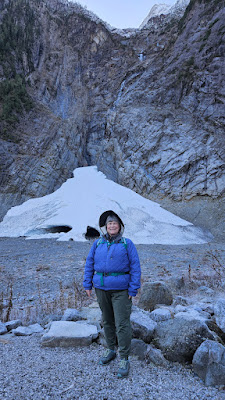
This is a pretty easy mile hike up to the ice caves. Large signs warn of the dangers of entering those caves and multiple people have been killed here over the years who ignored those warnings. I enjoyed the caves from a distance and a friendly couple took some pictures for me.
 |
| The ice caves look like a skull head or a partial ghost face |
I started back down the trail, enjoying the fancy frost finery that the bushes and trees wore.
 |
| fancy frost |
 |
| orange fungi |
 |
| New Bridge |
I took the trail towards the picnic area across a board walk through the marshes. The blue skies and views of the surrounding mountains were stunning. At one time, an inn called the Big 4 Inn stood in the area until it burned down in 1949.
 |
| The fireplace is all that remains of the Big Four Inn |
Historical markers describe the history of the area and I learned the history of the name The Big Four. I thought it was from the four peaks of the mountain but it comes from a geographical feature that looks like an enormous four. An old picture on one of the placards clearly shows it almost a hundred years ago.
 |
| Can you see the 4 in the picture? |
After enjoying the history tour I continued down the highway towards Granite Falls. I stopped at Robe Canyon where I did another 2 mile hike and then headed home. It was a beautiful day of exploration and solitude.


