Search This Blog

Wednesday, December 21, 2022

Winter Wonderland

Snow started falling on Whidbey Island on Sunday night and by Tuesday morning we had over six inches at my home in Coupeville.


Around noon I pulled on my new lined Eddie Bauer pants from Costco, laced up my snow boots and headed down the road to Kettles Trails. Almost no traffic was out along Libbey and I cut across the road and into the forest. 


The woods were eerily quiet and besides the deer, bunnies and birds, mine were the only human footprints. I stopped and filled my mouth with the snow off a bush, the crisp taste taking me back to my childhood. Occasionally a tree would shiver and then snow would rain down on me as the trees playfully threw snowballs from their branches.


A snow covered mound on top of a trail marker revealed itself to be a small hand saw after I brushed the snow away. It looked like a gun. This section of the trails used to have a homeless encampment here and the trail name, Breaking Bad, is perhaps a tongue in check reference to that history. The land was donated to Island County a few years ago and the homeless have moved out as the trails were constructed and the local mountain bikers and hikers took the area over.


I gazed upwards, enjoying the view of the snow covered trees. Occasionally the red bark of a madrona tree wending its way towards the sun broke the monochromatic view of brown and white. 

Hiking through six inches of snow is hard work. I wished I'd thought to bring my hiking poles with me when I approached a steeper part of the trail, and then I reluctantly turned to begin circling back home.

As I popped out onto the old road I saw that several large trees had fallen. They had been cut off the trail and I was appreciative that I did not have to try to go over or around them. Island County, along with the local bike group, has done a fairly good job of stewarding these trails. I'd love to see a better clean up of the homeless encampment occur. Old wood pallets and detritus still scar the land in places.

Downed trees

I trudged through the snow, eventually rejoining my original footsteps, and I saw a chipmunk scurry around a tree trunk and birds began to flit through the trees and shrubs. The snow crunched beneath my boots as I hiked down Libbey Road towards my house and as I arrived, John opened the door for me, welcoming me back into the warmth of home.

Saturday, October 1, 2022

People and Marmots and Bears, Oh My!

Rated the most beautiful hike in Washington, Cascade Pass has been on my hiking list for several years. So when I learned that the road had been repaired to the trailhead this summer, I decided this was the year to do it. When I heard that a small rain shower was going to clear out smoke and that Saturday, September 24 the conditions would be perfect for great views but not too warm, I put out the word to my hiking group at school and Russ and Angie decided to join in the fun.

Russ picked me up and we met Angie in Oak Harbor and headed from Whidbey Island to Marblemount. Angie tries to do this hike every year because it is her favorite and it was nice to have someone along who knew how to get there. When we arrived in Marblemount we headed straight across the one lane bridge on Cascade River Road and up the road to the trailhead. The road was paved part of the way and then became gravel but was in surprisingly good condition. The views, even on the way up, just got better and better, a preview of what lay ahead.

Russ and Ang get hiking shoes on
We arrived at the trail head and had to park about a half mile down the road since the parking lot was full. There were lots of cars and lots of people. Even in the parking lot the views of the mountains were amazing.


As we put on our shoes and suntan lotion we suddenly heard a rumbling and realized that up above there had been a small avalanche. We paused for a beginning picture at the beginning of the trail and then started the multiple gentle switchbacks up the mountainside. The trail was soft beneath our feet as we climbed gradually out of the trees.
My goal was to hike to Cascade Pass, but Russ and Angela were going to attempt to make it to Sahale Glacier. 
We paused for a water and snack break at the bend of one of the switchbacks that had a clear view back down the valley. Snow glistened on the mountain top glaciers.

Eventually we broke out of the trees and began a more level traverse, crossing a large talus field. The only running water for drinking was along this section, about three mile in.
After that traverse we crested Cascade Pass. We could look down the valley toward Stehekin. There were several large rocks for people to sit on, and people milled around taking pictures of themselves and the views. A path led up the hill with a small toilet sign. Tucked back off that path was a plastic compostable toilet with a view. Bring your own toilet paper.

We settled on the steps leading up to the toilet and began to eat our lunches. The Angela saw a Volvo key lying on the ground. Oh no, someone had lost their car key! We asked the people standing around but it did not belong to any of them. There was a metal survey marker that we laid the key on, hoping the owner would see it if they came back past it, and decided that if it was still there later we would take it down and try to find the car and leave it there.

We settled back down to finish our lunches and Angela suddenly saw that there was a bear about 30 yards from us, munching on blueberry plants. I got a picture of it and then we skedaddled up the trail. Even though Angela and I were both carrying bear spray, that was too close for comfort.
Russ and Angela continued up towards Sahale Glacier and I climbed up a ways before turning around and returning to Cascade Pass to wait for them. The black bear had ambled away when I returned and I sat on the rocks and chatted with some of the international hikers that were taking pictures there. A hiker saw the key and said he'd take it down and try to find the car that it went with and leave it there.

Eventually Russ and Angela returned and we headed back down the trail.


When we finally reach the bottom we passed the car that the key belonged to. There was a thick layer of dust on the back window and the kind hiker had written a coded message in the dust and hidden the key under a water bottle and some foliage on the front window. I hope the people figured it out. From the amount of dust on the back window the car may have been there a few days.

We drove back towards Whidbey, stopping for a fabulous dinner at the Train Wreck, where we ran into a couple of the hikers we'd met at the top of Cascade Pass. What a fabulous hike! Great time with great people and great views. It does not get much better than that!


Sunday, September 11, 2022

Walking Ebey

 A few weeks ago I read an article in the Whidbey New Times highlighting a new hiking trail near Coupeville. Last week as I drove to the ferry I saw this new trailhead and decided that I needed to go explore it. The trail is called Walking Ebey and it connects Admiralty Inlet via a 3.5 mile trail over to Rhododendron County Park. This trail was created by the Whidbey Camano Island Land Trust and crosses the property of 12 private property owners, so hikers need to be very respectful of the properties, obey all posted signs, pick up after dogs and leave agricultural things alone.

Friday after work, my friend Sue and I decided to check out this new trail. We parked at the new parking lot off of Engle Road and then perused the kiosk information board, choosing to take the Prairie Wayside trail for a 3 mile round trip.


We hiked along pastoral farms, listening to the cries of a hawk, enjoying blackberries and debriefing about the craziness of our day at school, which involved a fire evacuation practice, an unexpected lockdown due to a bank robber who apparently strolled right past our school with his gun, multiple fights and kids having meltdowns. Later when I got home I checked the lunar schedule and we are one day away from a full moon. Craziness explained.

I was happy to see Prairie Wayside highlighted on this trail. It is a little utilized wayside station with one picnic table and an information kiosk just off Engle Road. Sue had never stopped there, despite living in Coupeville for more than 15 years. I have visited this Wayside before and was surprised to find, five years ago, tucked at the very end of an almost unused path, an informational plaque that highlighted the "covenant" that local landowners made over 100 years ago to not rent to any Asians. I took Sue down to this plaque and was not surprised to see that informational plaque is now blank. I mean, what community wants their racist history highlighted, especially naming the families that made that "covenant," some of which are still quite well known names in Coupeville? 

We returned to our cars but I was longing to explore the rest of trail so the next morning I pulled on my running shoes and returned. I wanted to get an early start because smoke was heading our way from eastern Washington. This time, I stayed on the main trail instead of taking the cutoff for Prairie Wayside. I saw a coyote run across the trail ahead of me and I made sure to sing loudly as I approached where I had seen it, not wanting to surprise it.


I jogged along the path, enjoying the farmland scenery. It reminded me of hiking in Scotland this summer, where some of that trail went through farms and the expectation is that people can walk anywhere but everyone is respectful of farmland and animals and careful to close gates. There are no gates on this trail, however, that need to be closed.

Look closely and you will see the hawk in the sky

The trail was pretty well marked, with no trespassing signs at junctures that could have been confusing.


It was interesting to have the opportunity to see Ebey Prairie from a different angle and to see areas that I had never seen before. I passed a farmer watering his baby filbert trees. This dry weather has been hard on them and their leaves were starting to turn brown. I took the opportunity to thank him for letting hikers go on his land and he, too, seemed excited about this new hiking opportunity.


Eventually, at about the 2 mile mark, the trail crossed Fort Casey Road. The trail was not as clearly marked at that point and I went to the right but the trail petered out. I decided to turn around and return to the car. Looking at the map again, I realize I should have actually gone to the left, but the rest of this trail will need to be explored at another time.

Shortly before I got back to my car a huge owl swooped over the path and landed in a tree. I managed to snap a picture of it, and was told by another hike at the trailhead that there is an owl who nests in that area.

Can you see the owl?
Eventually, more miles will be added to this trail. The Prairie Wayside trail will become a loop trail back to the parking lot and there will also be a trail down to South Main Street in Coupeville. Some other day this week, once the smoke has cleared out, I will hike the rest of the trail starting from Rhododendron Park to Fort Casey Road. I love having hikes to look forward to!


Scotland and the West Highland Way

I had the opportunity to go to Scotland with my friend Pounce and hike the 96 mile West Highland Way this summer. To say it was epic is really almost an understatement. I thought I would try to blog about my experience, and maybe at some point I will, but my fabulous sister took my pictures and videos and made a video of it. Here is the link to see that video.

https://vimeo.com/743865869/9f9157dddb

Tuesday, July 5, 2022

Day 9 West Highland Way - Kinlochleven to Fort William

 Tuesday, July 5, 2022 Kinlochleven to Fort William, mile 96, 16 miles 

We fixed ourselves breakfast down in the hostel kitchen. I kinda like the hostel thing. It is affordable and you meet interesting people from all over the world. All the hostels I've experienced on this trip have had a laid back vibe. Our four person bunk room had bunk beds in it but tall people must struggle. Each bunk was barely six feet long. There are not many advantages to being short, but being able to fit onto almost any bed is one of them. It also would have been a tight fit to have had two additional people in that room. It was really nice to be able to hang out things everywhere to dry without worrying about any other roommates.

My tent in the hallway had dried over night and we packed my gear and quite a bit of Pounce's into my backpack. I took the detachable lid off and used it as a fanny pack for the day. I carried my fleece, food, Garmin and water bottle in it. Pounce had her pack but without all her gear it was almost like a day pack.

full pack ready for transport by Ginger Routes

We signed the chalkboard in the hostel kitchen and got our passports stamped. By 9:00am we were on the trail since we had a 16 mile day ahead of us. We were excited to do this section without our heavy packs. Many people do this trail using a daily baggage service. They book their lodging in advance and just carry a day pack with their food, beverages and extra clothes. The advantage of this is they know where they will be staying each night and their luggage is waiting for them at their hotel when they arrive. The disadvantage is that there is no room for spontaneity and the lodging is typically not refundable if you get injured or need to change your hiking plans. You also miss out on great camping opportunities and it costs a lot more money. But with how rainy it is I would maybe go with a luggage service and prebook my rooms if I was to ever do this again.

I don't get it, the trail looked so flat on the map

I signed the date the European way


When the board gets too full they take a picture of it, post it below the wall and start over

Starting the final day


climbing up out of the valley
The day started with a steep climb. It was probably just as steep as Devil's Staircase, but nobody really talks about this section. It was no problem without my heavy pack.
Kinlochleven behind us


The two small white buildings on the hills are where the trail started to descend to Kinlochleven yesterday

It spritzed rain and after we made it to the top we began the drover or military road to Fort William. It was nice and wide and in pretty good shape. The sun came out and the layers came off until I even zipped off my trousers bottoms. In Scotland we call them trousers not pants. Pants mean underwear here.
the layers are coming off

It was beautiful moorland with hills, green and sheep. There were tons of hikers today that we kept leapfrogging and views for miles! After the first rain of the morning it was sunny and warm the rest of the day.
puddles on the trail


Tigh-na-sleubhaich
It is not advised to wild camp inside this old derelict farm house, but just past it are some rock walls of a former sheep pen that provide shelter form the wind. We did not stay here but it looked good.
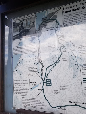
Lundavra /Lochan Lunn Da-Bhra

This little lake was where the real McBeth lived at one time.


Looking back towards Big Pass and Lundavra 


It felt like we were walking in The Sound of Music scenery

Gazing at Ben Nevis the highest point in Scotland

Ben Nevis

Descending to Fort William


We arrived at Fort William in the late afternoon. It was jarring to be walking the last few miles on concrete sidewalks next to busy traffic so when we saw a side trail to the city we took that instead. It gave us beautiful views of Fort William and I do not understand why that is not the official trail, other then they want the hikers to go through the commercial part of Fort William and spend money. 


We rejoined the West Highland Way for the last mile or so. The final part was on a brick road that passed lots of tourist stores.


I am done!

The end of the 96 mile West Highland Way