Search This Blog

Friday, July 24, 2015

The Great Alaskan Adventure - Driving the AlCan

I read once that everyone should travel the Al-Can before they die. I can now check this off my bucket list. The Al-Can is the Alaska Canadian Highway, an isolated, ruggedly beautiful road that connects the lower 48 with Alaska via Canada's British Columbia and Yukon Territory. It was built during World War II to create a roadway to the Alaskan Territory. Many people don't realize that parts of Alaska were actually occupied by the Japanese during World War II, and the hastily constructed road had significant military importance as a supply line. Since then the gravel road has been paved and although the frost heaves (places where the pavement buckles because of the permafrost and winter weather) create yearly maintenance challenges, the road is actually in pretty good shape.

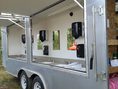
I was two days away from backpacking another section of the Pacific Crest Trail with my cousin, Kelley, when I got a call from my brother, Donald, asking me to go to Alaska to run his hand-wash trailer. He owns trailers that are rented during fire season to help firefighters have a place with warm water to wash their hands, which helps keep them healthy. Two days later he picked me up in Mt. Vernon, Washington, and we headed to Alaska, towing the trailer.
Donald and I 
We took Interstate 5 north and entered Canada at the Peace Arch. Donald did the bulk of the driving during the trip, which was great for me as I gazed at the scenery and kept track of our progress on the map. The high cliffs of the Fraser River Valley reminded me of the Columbia Gorge as we took Highway 1 north to connect to Highway 97. We passed river rafters as we hugged the Fraser River and then continued north along the Thompson River. The scenery along the Thompson was much drier than I expected, similar to eastern Washington. It was blazing hot and the thermometer eventually read 103 degrees. The air was smoky from a huge wildfire. 

For dinner we stopped in Prince George and then headed west on Highway 16. I drove a few hours while Donald napped and then he took over again and we drove until 11:00 pm, stopping for the night at the Shady Rest RV Park in Houston, B.C. 

The next morning we were up and out before 6:00, getting coffee at the local 7-11 and driving past a lovely ski resort before turning north on highway 37. Highway 37 is a rather rustic paved road, without any painted shoulder or center lines. I saw my first moose along this road, crossing a stream. The wildlife count would later include a momma black bear with two small cubs, a brown bear, two bison, a cow elk with calf and numerous squirrels.
A rainbow ahead

The sign at the turn off to highway 37
We gassed up the truck at every available opportunity since we never knew where the next gas would be. Highway 37 seemed like a very long section. Finally we entered the Yukon Territory and connected with Highway 1, the official Al-Can. Along the road people had spelled out their names using the rocks. Because we were in a hurry we didn't stop to do the same, although we did pause briefly at the Continental Divide Marker.
Raining at the Continental Divide
We stopped for dinner in Whitehorse and it seemed surreal to me to actually be in a place that I'd seen on Gold Rush and Ice Road Truckers. We continued on to my favorite part of the trip, Kluane Lake.
Donald drives near Whitehorse


10 o'clock at night and the sun is still up!
The sun set at midnight in an array of stunning colors and this was my first experience with the northern midnight sun. 
midnight at Kluane Lake


mist on Kluane Lake
Driving around Kluane Lake we kept an eye out for the frost heaves. Some parts were in gravel in preparation for paving. Eventually we pulled over at a rest area and slept for several hours.
full moon rising over Kluane Lake at midnight
After several hours of sleep, we got up and continued, stopping for breakfast and coffee at Ida's in Beaver Creek. We shared an order of caribou sausage hash as we updated our statuses on Facebook using the free WiFi.
breakfast with free wifi
Several miles later we crossed the border into Alaska and sighed with relief at the well maintained road on the American side. About 30 miles in we were flagged down by a man on the side of the road trying to get a jump for his truck. We didn't have any jumper cables, but Donald tried to jump him with his spare battery from the trailer. It didn't really work but we all flagged down another vehicle which did have jumper cables. It ended up that the man was a veteran who had actually lived on Whidbey Island at one point in time. Small world!

We rolled in to Fairbanks around 2:00 pm and scouted out a place to buy a shower. After showering, Don's son Zack met us and my trailer ended up being dispatched to the same fire that Zack was already on with Donald's other hand-wash station, the Aggie Creek Fire. What a blessing to be able to have the two trailers on the same fire! Zack's trailer was down by the mess tent and mine was placed up above where every one was camped.
Donald puts a few finishing touches on this new trailer. I slept inside the trailer on the cot. 

We are up and ready for business
It was an amazing experience to drive over 2,400 miles in three days. I never realized that British Columbia and the Yukon Territory are bigger than the American west coast of California, Oregon and Washington. From hanging out with my brother, to seeing wildlife and experiencing Canada and Alaska, the drive has been unforgettable.

2 comments:

  1. Looks like a great experience! I came across your blog via WTA, I believe. I'm also doing a lot of hiking and backpacking in my 50th year. I live in Mount Vernon, small world.

    ReplyDelete
  2. Forgot to check the "notify me" box.

    ReplyDelete